About the Port
Promoting economic growth since 1940
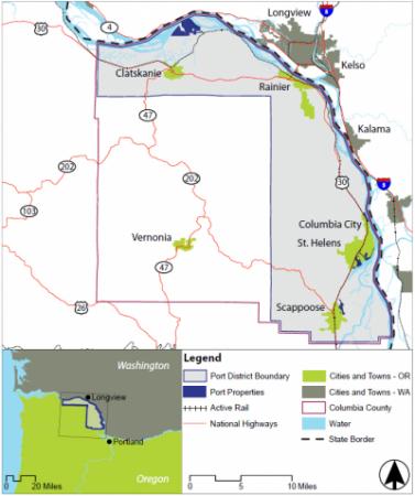
The Port of Columbia County is a special district in Columbia County, Oregon. The boundaries of the Port District span 51 miles along the Columbia River from the Clatsop County line in the northwest of Columbia County, to the Multnomah County line in the southeast, and includes the cities of Scappoose, St. Helens, Columbia City, Rainier, and Clatskanie.
The Port was created in 1940 under Oregon Revised Statute (ORS) Chapter 777 to promote economic development in the Port District, primarily through the lease and development of industrial property. Port dollars are used to purchase and develop land, infrastructure, and facilities. The Port plays a significant role in the attraction, retention, and expansion of businesses, resulting in job growth and increasing the local tax base.
Originally called the Port of St. Helens, the Port was renamed in 2018 to be more representative of the entire district. Today, the Port of Columbia County owns 8 industrial properties with 2,400 acres, including sites with excellent highway, rail, airport, and maritime access. The Port also owns and manages recreational properties at Scappoose Airport, Scappoose Bay Marine Park, and Bayport RV Park & Campground.
Vision
A diverse regional economy with thriving local businesses, quality jobs, and opportunities for all.
Mission Statement
Create a positive economic impact while maintaining livability and adapting to change.
Guiding Principles
Fiscal Responsibility
Environmental Sustainability
Adaptability
Accountability
Integrity
Opportunities for All

